Our Route: Fuessen to Munich, Dachau, Augsburg and then on to Salzburg, Austria
Fussen
Fussen im Allgäu is an enchanting border town in Bavaria, wellknown for the Hohes Schloss and its Basilica and the former Benedictine Monastery of St Mang. The town borders with Austria
Entering Germany at fussen
Munich City
the Capital City of Germany is one of the world's great beer and brewing capitals of Europe. This is best seen in its vibrant beer halls during the annual Oktoberfest or at a beer garden during the summer. You can visit Baroque and Renaissance cathedrals and opulent royal palaces dating back between the 12th and 18th centuries.
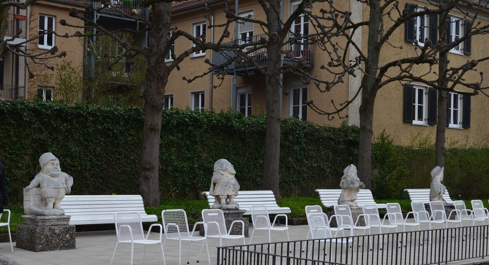
 The Ruhmeshalle or The Hall of fame and The Bavaria Statue at the Bavaria Park. Our Sorento found a safe parking spot near the park while we go on a Walking tour of Munich
With Our Sorento safely parked opposite The Bavaria Park, we went on an evening walk of Old Munich City and headed straight for Munich's famed Beer Hall/Tavern The Hofbrauhaus built in 1589 is a brewery in Munich, owned by the Bavarian State Government. Its the highlight of the evening.

 A man and his horse statue
 Alte Pinakothek - is an art museum located in the Kunstareal area in Munich, Germany
Mariam's Column

Juliet Capulet Statue
It is located in the historic area of Munich near the Glockenspiel as well as a shopping area.  Viktualienmarkt offers gourmet food stalls and a beer garden.
The Angel of Peace Column Old Munich. The Angel on top of the coulmn is a female figure of a Greek goddess of victory to celebrate the Franco Prussian War
Leaving Munich for Dachau
Dachau
Dachau Concentration Camp was first established in March 1933 by the Nazi Government, near Munich, for political prisoners." Later others including Roma gypsies and homosexuals, as well as Jews were brought to Dachau.
At Dachau German doctors and scientists set up laboratories using inmates to carry out heinous and macabre experiments.
Dachau one of the most notorious of Nazi Concentration Camps during WWII.
Dachau Village, located just north of Munich is a town made famous due its promixity to a Nazi Concentration camp where tens of thousands of prisioners were gassed, killed or tortured to death during WW2.
American troops liberated Dachau on April 29, 1945. Among their most-gruesome discoveries were railroad cars filled with Jewish prisoners who had died en route to the camp and had been left to decompose.
Ausburg City
Ausburg in Bavaria is one of Germany’s oldest Cities. It lies at the junction of the Wertach and Lech Rivers. The Old Town includes medieval houses, the 11th-century St. Mary's Cathedral and the onion-domed Basilica of St. Ulrich.
Arriving at Augsburg
St Mark's Church in the Fuggerei settlement
The Fuggerei is the world's oldest social housing complex still in use. It is a walled enclave within the city of Augsburg. Above is a few of the 67 buildings built by Jakob Fugger In 1517, Its Fugger’s vision , which he created as a way of providing affordable homes for day laborers, artisans and their families. Strict conditions were attached for those who wish to rent the house he built. Only for local Roman Catholics. the rentof 0.88 Euro per year had never been raised since the 15 centuary
Mustard coloured houses adorned with overgrown vines.
Jakobsplatz, Statue of Neptune and Dolpin
St, Peter and Perlach Church located directly opposite the town hall, one of the oldest churches in Augsburg, it was built around 1700.A beautiful painting of the Virgin Mary Undoer of Knots, can be found in the Church, depicts the Virgin Mary taking the knots out of a long white ribbon.
Or Augsburg Registry Office....
15 Centuary Historic Weberhaus
Mansions and private houses built by the wealthy Burghers of Augsburg during the Renaissance period.
The Basilica of SS. Ulrich and Afra is a Catholic parish in Augsburg. The building is a great example of Gothic architecture in Germany, its high bell tower with an “onion”dominates the city
Entrance to The Der Hoffmein Garden
Der Hoffmein Garden a beautiful small park in Old Town Augsburg.
Figurine statues in the Der Hoffmein Garden
Driving out of Ausburg to Freilassing
The German Totem Pole in Bavaria
Antique car
Germany - 2018
In 2018 we overlanded from Vladivostok, Russia through Mongilia, exiting at the western border of Mongolia at Tsaarganur to the Baltics at Latvia and then the Scandinavian Countries at Helsinki, Finlandt then entering Germany from Denmark
Germany is a vast Country stretching from Northern Central Europe to the borders with Fance and Switzerland in the South in Europe. Germany is famed for its cars like Audi, Mercedes, BMW and the Volkswagen. It also has some the most scenic routes in Europe.
This is our 2nd Overland trip in 2018 in Our Sorento.
Approaching the Border near Tonder/Saed /Sunderlugum Northwest Germany from Denmark.
Husum Town is also known as Husum Bay. A pretty little German seaside town. The town made famous as the gateway to the wadden Sea , a UNESCO World Heritage Site.
Exploring the Town on wheels
Pretty thatch roof House
Hamburg City
The City of Humburg lies on the River Elbe, is located in the North of the country, 150 km from Husum and 200km from the border with Denmark. It is also referred to as The Gateway to the World, being Germany's biggest Port and second busiest port in Europe despite it being 100km from the North Sea
The Monument of Emperor Wilheim1
King of Prussia. He became the first German Emperor in 1871A bronze equestrian statue of Wilheim 1 with statues of female warrior figures, a fisherman (representing Trade and Navigation) and the Blacksmith (representing Industry).
The Kohlbrand Bridge is a cable-stayed bridge in Hamburg, Germany It connects the harbor area on the island of Wilhelmsburg between the Norderelbe and Süderelbe branches of the Elbe River with A7
Visitng the Hamburg Fish Market
At the Fish market area. walking around we found this Fish Bistro still open that is quite popular with tourists.
Fried fillet with potatos and serving of salad
Our early dinner at Fabio's Fish Bistro
Leave Hamburg for Spandau, our target destinations, Berlin, Thale and the Black Forest Scenic Route Triberg etc
Berlin City
Berlin is the Capital of Germany popular with tourists from all over the World. The Berlin Wall, The Victory Column, the Brandenburg Gate The Reich-Tag , all within walking distance,are must see sights in the German Capital. Berlin's long and turbulent history is now a world city reknown for its technolog as in Mercedes, BMW and The Iconic Volkswagen Beetle Cars etc
The Berlin Victory Column
is located at the central square in the Tiergarten Park The Column is also called Der Grobe Stern , The Great Star. The Bronze Statue atop of the Column is a victory symbol, a statue of a Goddess
The Berlin Victory Column
The Berlin Victory Column also called the Arco de la Victoria topped with bronze statue. Built in1873 to celeberate the Prussian victoryin the Franco German War
Tiergarten Park.
Taking a stroll through the Park back to where Our Sorento was parked.
Driving tour to The Victory Column, the Brandenburg Arch, Reich-tag and The Berlin Wall site
The Glass Dome of The Reich-tag Building

The Brandenburg Gate
An iconic sight not to be missed by tourists, The Brandenburg Gate is historic as it symbolises the division of Berlin City into East and West Berlin and East and West Germany with two differing ideologies.
The Berlin Wall was constructed in 1961 out of the Cold War. The Brandenburg Gate was walled inside East Germany.
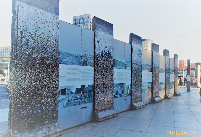
The Berlin Wall/ The Iron Curtain
Berlin Wall, built in 1961 by the Communist to primarily deter defections from Socialist East Germany to Free West Germany. Also called "The Iron Curtain the fall began with mass protest by the people of East Germany in 1989. It was finally demolished in 1991 with fall of Communism that also saw the ending the Cold War. It also reunified the two Germans into one Germany soon after.
Our Overland route from Berlin, Madenburg to Thale, to Rottenburg ob der Tauber on to Baden Baden to start the Black Forest/ The Clock Route
Madgeburg City
Cathedral of Saints Maurice and Catherine: Dom Zu Madgebur
The Hundertwasser Building also called The Green Citidal Of Magdeburg
Madgeburg, Elbe River on the Left
Thale Town
The little pretty Village of Thale, nestles in the scenic Bode Valley of the Harz Mountains, Thale is situated on the River Bode 8km west of Quedlinburg. Famed for its Waterfall and Tales of Witchcrafts
Beautifully decorated town house in Thale Village.
Bamberg City
is one of Germany's most beautiful Towns, its Old Town has been a UNESCO World Heritage Site since 1993, with Bamberg being home to Europe's largest intact old city wall.
The Naked Fat Lying Woman of Bamberg
is a bronze sculpture featuring Dionysus, a fat lying woman ancient Greek God of wine.

Cathedral of St Peter and St. George
Also called The Bamberg Cathedral is a Romanesque building with four imposing towers. It was founded in 1002 by the Emperor Henry II, and finished in 1012. mIt has a wooden Alter
The Red Sculpture of Bamberg
dubbed the "Meeting“ by Chinese artist Wang Shugang, with eight squatting men, in a circle on Schönleinsplatz Square.
Rottenburg ob der Taber
One of the many defensive Towers greeted us on our arrival to Rottenburg OTD City
The Tower was built about 400 years ago by the the King of Sweden They guard an idyllic town of plush houses and half-timbered dwellings, wooden bay windows, red roof tiles and blooming flowers boxes typical of many Villages and Towns along the Romantic Tourist Route T.
We will drive west to take the Scenic Clock Route in the Black Forest Region of South West Germany
Setting our GPS to drive on country roads rather then the highways will efford us a leisurely drive to Baden Baden enjoying the scenic countryside and the queint little Villages along the way.
Medival Tower Gates of Rottenburg O.D.T.
Another Tower Gate
We will drive west to take the Scenic Clock Route in the Black Forest Region of South West Germany
Setting our GPS to drive on country roads rather then the highways will efford us a leisurely drive to Baden Baden enjoying the scenic countryside and the queint little Villages along the way.

A trout farm in the Black Forest.
Beautiful Timber Houses near Bad Herrenbad Town
The Black Forest Mountain Range
is a located in the State of Baden- Wurttemburg in Southwes t Germany. It is bordered by theRhine Valley to the West and South. Its tallest peak is Mt. Feldberg at 1,493 metres.
Form North to South it is 160 kilometres The Black Forest is mainly rural, with many scattered villages and a few large towns. Tradition and custom are celebrated in many places in the form of annual festivities. tourists are drawn to The Black forest all year round mainly in the central and southern high region.
Black Forest Route from Triberg, Gutenburg, Walkirch, Freiburg to St Bleisan and Walshut
Sharing the beauty and wonder of Our Sorento"s drive through the Black Forest Villages and picturesque Valleys, green rolling meadows and narrow Mountains roads.
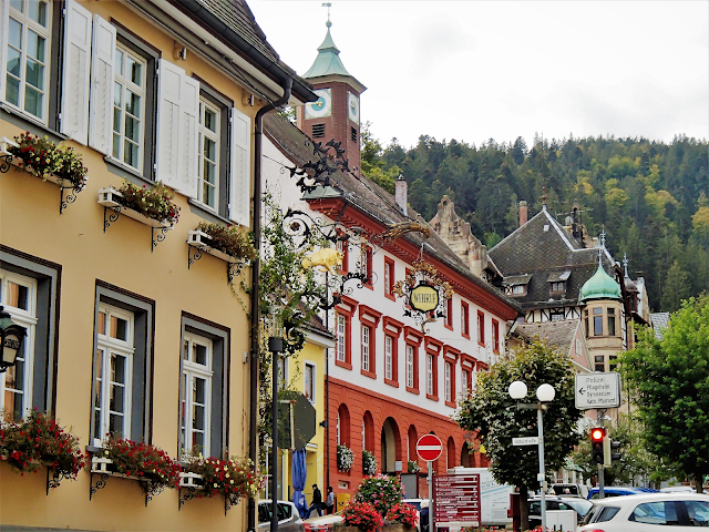
Triberg The Town of Cuckoo Clocks
Getting to Triberg town itself is a pleasant and satisfying experience , a worthwhile drive from Baden Baden that take us through numerous scenic valleys,villages and meadowsFrom Triberg we turn West to the through Gutenbach on The Clock Route , The Simonwald strecth of green rolling meadows and pastures.
Beergsee Lake outside Triberg
Driving to Furtwagan
Gutenbach Village
is famous for its historic Clock Museum. It was one of the centers of homebased manufacturing clocks in the Black Forest Region near the town of Furtwangen.Its exhibits the local history of clock making practised from centuries ago.
Outside Simonwald Village at a Viewpoint.
Picturesque Houses built on rolling meadow hills.
Simonswald Village
is located in the Simonswälder valley north-east of Waldkirch. The Simonswälder valley reaches up to 1,150 metre high Brend Mountain and Kandel Mountain 1,241 m,bordered by the huge mountains of the Southern Black Forest.
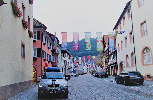
Waldkirch City
lies15 km east if the Elz River , perched at the foot of the Kandel Mountain, one of the highest mountain the Black Forest Region. Wlaldkirch is on the tourist German Clock Route, the route covers all the histroic villagesof Cuckoo Clock makers, wooden carvings, rolling meadows, villages and town and the senics views of green Valleys and meadows, beautiful pine forests, rivers and lakes.

Freiburg Town
is a Renaissance University Town along side beautiful historical buildings and squares. It is built on the Dreisem River. The Town sits at the foot of Schlossberg Mountains on the Western edge of Southern Germany Freiburg is also a hub for The Black Forest tourism due to its hinterland's scenic beauty, warm sunny climate, with easy access to the Black Forest's Towns of Triberg, Gutenberg, Simonwald, Waldkirch, Todtau, ,Bernau, and St. Blasein in the South with numerous pretty villages,rolling meadows and green valleys, ski resorts and cable car stations catering to tourists and travellers.
St. John Cathedral. Freiburg
Driving south on the scenic route to Todtnau, Bernau and St Blasein to Walshut
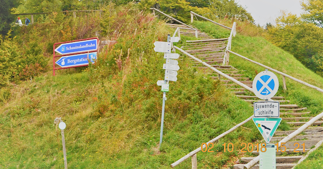
Schauinslandbahn Cable Car/Bergstation near Freiburg
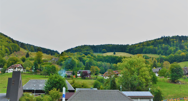
Just enjoying the scenic drive to Berneau and to the Swiss border
Muggenbrunn Village
A few more pretty Villages in Stats(District) Todtnau
Geshwend Village
St Blasein
Driving to the border town of Walshut
Georgia - 2013
Georgia though located far to the East of Of Istantbul Turkey is a European Country marooned more than 1000km in Asia. It's also part of the UNESCO World Heritage list.
Leaving Turkey to enter Georgia at the Sarp Border
On left is the Black Sea
Joining the que at the Turkish Customs and Immigration Check Point at Sarp, Turkey
We drive past Batumi Town …
Note the pipes ....water pipes above ground....
Water pipes crossing the road
River near Kobuleti Village
Rural Georgia
Kutasi City
On the right bank of the river Rioni, in Western Georgia. Dating back the 3th century B.C. Kutasi is one of the most ancient cities in the World and the third-most populous city in Georgia
This Fountain has 30 statues of the Colchis from the Kolkhida Digs that dates back to hundreds of years ago.
Statues and Monuments in Kuatasi
The Hatman on the Ronin River Bridge, Kuatasi
Note Our Sorento parked further down the street
Ronin River
Singing Maidens Statue
Flages of Georgia and EU.
Kutasi Sculptures
Bagrati Church
The Old Kuatasi
A rundown Church
An vintage Lada Suv?
Not taking the Wine Route road to Tblisi
Taking the rural dirt road out of Kutasi City, Georgia.
Abandoned Lada?
Georgia"s Mother Bread
The Georgian bread baked comes in different forms — round, oblong, with rounded-off corners. “dedis puri” or Mother's Bread ...
Modern Rest Area
CHEERIES
CHERRY TREE
SWEET SECCULANT RASBERRIES AND CHERRIES
Sweet secculant fresh Raspberry and Cherries
Sweet Georgian"apam balik"
Gori City
Gori is one of the oldest cities in Georgia, founded in the 7th century Gori City in eastern Georgia, is located at the confluence of two rivers, the Mtkvari and the Liakhvi.
Josef Stalin’s a former President of The USSR was born in Gori City
Stalin Park
Stalin's personnel Train
Josef Stalin was born in this house
Statue of Josef Stalin
Stalin Mueseum
Gori State Building
Odd Sculpture
A grandiose Architecture
Old Gori Fort
The road to Tblisi....our next City after Gori
Statues of Georgia"s Giant Knights in Gori , defenders of the Fortress.
Our Sorento is parked at the botoom of the photo
Mtvari River Bridge
Georgian Wooden Sculptures
Our takeaway Lunch
The River Mtyvari
Uplistiskhe. Rock Cave Houses...... outside Gori City
Inside a Rock Cave dewelling
Nature's handiwork
Bronze Sculpture
JVARI MONASTRY NEAR MTSKMETA
According to traditional accounts, the early 4th century Saint Nino, converted King Mirian III of Iberia to Christianity, erected a large wooden cross on the site of a pagan temple. The cross was reportedly able to work miracles and therefore drew pilgrims from all over the Caucasus. A small church was erected over the remnants of the wooden cross in 545 named the "Small Church of Jvari".
Mtskheta Tourist Centre and Food Court
Note the Malaysia made PROTON Persona with Iranian plate
SVETITSKHOVELI--CATHEDRAL OF THE 12 APOSTLE,
2nd largest Vatholic Cayhedral in Georgia is a A UNESCO heritage Site.
It is also known to be the burial site of Christ's Mantle, has long been the principal Georgian Church and remains one of the most venerated places of worship to this day. It presently functions as the seat of the Archbishop of Mtskheta and Tbilisi, who is also at the same time the Catholicos-Patriarch of All Georgia.
SVETITSKHOVEL CATHEDRAL IN MTSKHETA
Old Georgian 19the Centuary House at the Muesum of Ethnography in Chitala near Tblisi
Farmers'Houses
A nobleman's house
Welcome to Tiblisi City
Vake Park Tiblisi
Driving Tour of Tibilsi City
Old Tibilisi
Mother of Georgia Kartlis Deda stands all the way up on the hill and over-looking her capital. She is silent; a shining tall figure watching over Tbilisi.
The Dancing People ...A ancient pagan Mask Dance
The Baratashvili Bridge over the Mtkvari River in Tbilisi is decorated with bronze figures and is often referred to as the Bridge of Young Love,
Sameba Cathedral Sameba,
is the most important and majestic cathedral in Georgia. Rising on the hill of St. Elijah, the cathedral,The architecture of the cathedral is a combination of the old Georgian medieval church architecture traditions and new mordern designs.
Metekhi Cathedral,
Bronze sculptures around Tblisi City
Old Classic Car with Our Sorento parked in the background.
The Bridgeof Peace over the Kura River is mordern pedestrian bridge connecting the Old Town to the New Town of Tblisi and Narakel Fort in the background
Churchkhe Sweets filled different nuts and grape dried syrup
Cherries and raspsberry
Leaving Georgia for Armenia
Blosnisi Town ,Georgia
Country route out of Tblisi
Duguti Village/Armenia Border
Overland Travel blog on Armenia is under "A"
Leaving Turkey at Canakkale on 23 Sept 2012 and took the ferry across the Dardanelles to Kilitbahir. and Greece
Greece - 2012Once in Greece, we made our way towards Alexandrapolis and onwards to Kavala. We went past olive and cotton farms. We stayed out of the E90/A2 highway and took the inside roads as much as we can. Though two lane, the roads were pretty good and the zig zagging up and down rolling hills makes for a nice drive.

Queuing up to board the ferry from Canakkale to Kilitbahir.


Road leading us to Ipsala, border town with Greece.TURKEY / GREECE BORDER CROSSING:We crossed the border on 24 Sept 2012, having spent 27 days in Turkey. The exit from Turkey was quick except for a little delay having to go back and forth to find a border official to stamp our Carnet. Actually, Turkey does not require a Carnet for temporary importation of vehicle. However, as we had the Carnet stamped at entry, we had to get the officials to stamp it on exit or risk losing the deposit that we have placed for the Carnet at home.At the Greece border, the official asked us for our Green Card insurance before stamping our passport. We told him we did not have one and would like to buy them. The custom official told us to go back to the Turkish side and buy them there and then come back. Since we could not see any insurance booth on the Greece side, we made a u turn and drove back to the duty free shopping area on the Turkish side of the border and went in search of an insurance company. We found one and the guy told us that as our vehicle was not registered in Turkey, we could only be given a policy for 30 days maximum (we wanted to get a longer period to cover our stay in Europe and UK). He then told us that we can buy the same insurance at the Greece border for a cheaper price. So, we drove back to Greece and told the border official that we wanted to buy the insurance right there at the Greece border. It was only then that he pointed us to the office where we can buy the insurance. Wonder why he did not just point us to the office in the first place (there are no signage and it is one of the other border official who help issue the policy). We bought our 30 day cover for EUR180 and our passports duly stamped and we are allowed to enter Greece.
The highway, which we usually only use when the inside roads goes too far off course. Trying to recall all my mathematical symbols to read this sign board. No worries though, there is an English sign board just up ahead.
The inside road – just as good. Plus, we get to drive at a slower speed and enjoy the view.
Kavala City
Kavala city from the beach
Crystal clear waters rushing ashore from the Aegean Sea.
Another view of Kavala city Aqueduct of Kavala, or Kamares, is part of an impressive water supply system for the walled city expanding over 6km north of the city. The water springs from the so called “Mother of Water” and run in an open channel over single and double tier water bridges in very scenic landscapes. The need to bridge the two ends between the peninsular and the hills across led to the erection of this impressive structure which dates back to the 16th century.

Our Sorento and the Aqueduct of Kavala
Kavala city with the Castle of Kavala located at the top of the hill, overlooking the city below.

Boats docking along the Bay of Kavala
Pella

On our way to Pella.
Ancient city of Pella, once the capital of the ancient Macedonian kingdom in the early 4th Century BC. Read below for more info on the ancient city.

Alexander the Great Square in the modern city of Pella. The modern city is a short distance away from the ancient city of Pella, birthplace of Alexander the Great.
Statue of Alexander the Great in the modern city of Pella.
Orthodox Church in PellaROYAL TOMBS AT VERGINA:
The ancient burial mount (or tumulus) that is the royal tombs of the royal dynasty of Macedon. The mount measures 13m high and 110m across. Among the tombs here are those of King Philip II, father of Alexander the Great and a young prince called Alexander IV.

Entrance to the tomb. Unfortunately, photos are not allowed in the tomb. Inside, apart from the tombs, excavated artifacts that was buried with the royals in the tombs was also put on display.

Enjoying the view on the grounds of the ancient tombs.
From Vergina to Dion


Another church in the village of Palio Keramidi.

Here we are in Dion.

We saw a sign to Mount Olympus and am guessing that the mountain in the background could be the Olympus, the highest mountain in Greece.
From Dion to Agious demitiros
Olive plantations near Karitsa. Olives up close.
Came across quite a number of kiwi plantation in this region.
Agious Demitrios
Church in the village of Agios Dimitrios


A little restaurant / café.

Another restaurant / café. There were mostly men that we saw out and about in the village.
On to Metrios
Watch out for the pig crossing the road – near the village of Krania
Breakfast time for the little piglets and their mom.METEORA AND GREEK ORTHODOX MONASTERIES:We arrived at Meteora, a UNESCO world heritage site, and was greeted by steep cliffs and interesting rock formations. Meteora is home to more than 20 Greek Orthodox monasteries built centuries ago; only six remained today. These monasteries were built high on the rock cliffs only accessible by long ladders as the monks in those times found the rock cliffs to be safe from threat. When they felt threatened, the long ladders would be pulled up, cutting access to the monasteries by any unwelcomed visitors.
The Monastery of the Holy Trinity on top of a cliff – built in 1475 and was remodeled many times in 1684, 1689, 1692, 1741.
Rock cliffs in Meteora
Rock cliffs in Meteora. Notice the monasteries perched high on the rocks.

Rock cliffs in Meteora
Holy Monastery of Saint Barbera Roussanou from the view point.
Mum and dad. The building on mum’s left is the Holy Monastery of Saint Barbara Roussanou.HOLY MONASTERY OF SAINT BARBARA ROUSSANOU:
This monastery is one of six in Meteora. It is one of the two Greek Orthodox monasteries that are still inhabited by nuns. As the monastery was located on a rock cliff, we had to hike down from the view point and then make our way up the stair case into the monastery. It is here we learnt that centuries ago, hermit monks used to live in the rock hollows and caves of Meteora.

Staircase leading up to the monastery. 
Nice garden at the monastery
Bell tower at the monastery
Zig zagging trail leading us to the Holy Monastery of Saint Barbara RoussanouHere are some pics en route to Delphi.
Came across this kantina on the roadside at noon. Since it is lunch time, we decided to try out the food.
Dad looking at what to order.
British Military Cemetery at Bralo
British Military Cemetery at BraloDELPHI:
Streets of Delphi
Streets of Delphi. We had pancakes, ice cream, cold beer for dad, coffees for mum and I at this cafe.DELPHI ARCHAEOLOGICAL MUSEUM / SITE:As we were a little late, the museum was closed. Luckily for us, the archeological site was still open. The entrance fee for the site is 6 Euro. However, as it was European Heritage Day, entrance to the site was free.
Some info on Delphi archaeological site.Here are some pics of the archeological site / museum.

Artifacts at the entrance of the Museum.
The Treasury of the Athenians. See photo below for more info.
Temple of Apollo
Background of the Temple of Apollo
The theatre (seen from above) is situated high on the hill slope with a stunning view of the hills and valleys below. Its 35 rows of seat can accommodate 5,000 spectators.
The stadium.
The other end of the stadium
Some info on the stadium
Inscriptions on stone.
Stunning view of the valley below.Athens, Greece (30 Sept 2012)
Leisurely drive from Athens to Ioannina, Greece (1-5 Oct 2012)
We left Athens and made our way west, driving along the coastal road towards the city of Patra. At Kamari beach near Kineta, we camped for two nights and whiled our time away swimming in the cool waters of the Gulf of Corinth, reading, studying our route and watching locals fishing. Mum and dad took long morning walks along the beach taking in the clear waters and beautiful people. Mum made pancakes for breakfast and we ate them with honey we bought in Turkey. Next, we made our way to Lykopria, Diakoplo, Kamares and Rodini.
Beach front houses facing the Gulf of Corinth.
Dad chit chatting with a local family near Rodini
_________ _ __________
On Oct 4th, we arrived at Patra and wanted to take the ferry across to Antirrio. Unfortunately, our GPS took us to the wrong ferry terminal. The locals were not helpful at all and the few we managed to speak to pointed in all directions, each different from the previous person. After driving to two terminals, at the third one (the one next to the Rio-Antirrio Bridge) we managed to get the right ferry and made our crossing.
Our Sorento onboard the ferry that will take us to Antirrio.
Rio-Antirrio Bridge – world’s longest multi-span cable-stayed bridge. Located in an area with high seismic activity, this bridge is considered an engineering masterpiece. To accommodate tectonic movements, the piers have been built to slide on their gravel beds. We made the crossing from Patra to the mainland via ferry as it was cheaper and comes with a good view of the bridge too.
Once on the mainland, we headed north west. At noon, we crossed the Evinos Bridge and came across the ruins of the Ancient city of Kalydon. Driving from Evinos to Astakos, drove passed olive farms, beaches, rolling hills and mountains.
Ancient city of Kalydon, located west of the Evinos Bridge
_________ _ __________
We reached Astakos at 6pm. There were lots of luxury yachts from other European countries docked here. Astakos is also a fishing port and distribution centre. We met and chatted with a couple from Holland who were having home made dinner complete with wine just outside their caravan.
Along the bay, anglers were trying their luck – a lady angler caught some fishes but kept throwing them back into the crystal clear waters below, probably just to while away her time before bed. We treated ourselves to seafood dinner with fresh calamaries and fish roe salad. Astakos means lobster in Greek, but we did not see any lobsters around.
Astakos
. On the next day, we continued our journey round the bay of Astakos towards Palairos keeping to the coast of the Ionian sea. The landscape is one of rugged bare rocks layered with the occasional patches of green with goats and cows grazing on one side and on the other great views of the rocky beaches of the Ionian Sea
.
Not something you see everyday - Goats sunbathing!
Slightly narrow but very good roads along the coast of the Ionian Sea. Traffic is so few and far between, making this one of the most relaxing scenic drive.
Rocky beaches, taken about 9km south of Palairos.
Another view of the coastline. Also taken less than 9km south of Palairos
By noon, we reached Vonitsa and stopped at a local bakery for some cakes, croissants and bread. The owner could speak English and gave us a little history lesson on the Greek Orthodox religion.
This bread with sesame topping is made only for special days (eg. name day). On the day itself, the bread will be brought to the Greek Orthodox church. After blessing with wine, the priest will break the bread and offer it to the church goers. On not so jovial occasions (like a funeral), a similar bread minus the sesame topping will be brought to church for blessings and later shared. These breads used to be made at home, but these days, some prefer to order them from the bakery instead.
_________ _ __________
Next, we headed to Aktio, on the Ambracian gulf, where a wrong turn took us into Cleopatra Marina with luxury boats and yachts of all sizes bobbing up and down to the rhythm of the waves. It is windy and cold here.
Retracing back our steps we managed to find the right road and took the undersea tunnel to Preveza. We then made our way north to Ioannina, stopping mid way at Befra for some pastries and pizzas.
Tea break at this unoccupied hut facing the Ambracian Gulf.
Ancient Nikopolis, taken at the roundabout about 8km north of Preveza.
Ioannina, Greece (6-7 Oct 2012)
Ioannina is a castle town located on the banks of Lake Pamvotida and is our last stop in Greece before we cross the border to Albania. We arrived on Saturday and since we make it a point to only cross borders on weekdays, we had two days to walk the streets of Ioannina.
The city is very pretty with lots of old trees lining the banks of the lake and colourful rows of shops and houses. The city is lively with many cafes and restaurants to while our time away.
Byzantine Medieval Fortress
Outside walls of the medieval fortress
Clock tower
Another view of the clock tower One of the entrance / exit points
Pretty streets of Ioannina
Mum & dad enjoying dinner
Greece / Albania border crossing and onwards to Gjirokaster (8 Oct 2012)
We made our way from Kalpaki (Greece) towards Kakavia, the border town with Albania, in the morning.
We had earlier read on the internet that EUR10 per person tax on entry is chargeable for driving into Albania. On exit a further EUR2/day each will be levied. So, we were ready with some small change. However, the Albanian border police checked our passport, recorded Our Sorento registration details and within minutes cleared us without asking for any payment.
We stopped a few metres away to check that our passport are all in order before leaving the border post – mum’s passport was not stamped. We walked the short distance back to the border police and got it stamped.
We also bought third party insurance for 15 days (EUR40) and exchanged some Euros for the local currency, Albanian Lek, before making our way onto highway SH4 to Gjirokaster.
Albania is posted under A


 (1024x678)")
")


")


")
")
")
")
")
")
")
")
")
")
")
")
")
")

No comments:
Post a Comment