
Enterd Kyrgyzstan from Uzbekistan
Kyrgyzstan 2013
We left the Uzbekistan / Kyrgyzstan border after going through customs and immigration at around 3pm. We drove along the A373 to the city of Osh, located less than 10km away from the border.
Watch our videos on our Youtube channel >> https://www.youtube.com/channel/UCkuvmagkyCY-XqWZEKUOm-w


As we enter the city of Osh, we were greeted by the towering Sulaiman Too or Mount Solomon. Once a beacon for ancient travellers and tradesmen travelling on the old Silk Road, Sulaiman Too was the first site in Kyrgyzstan to be inscribed on the UNESCO World Heritage Site list. The mountain is revered as a sacred mountain and legend has it that Prophet Muhammad once prayed here.
After checking in, we had a lazy day in our hotel at Osh city. The next day we did a bit of sightseeing before leaving Osh to head north towards Bishkek. Capital of the south of Kyrgyzstan, Osh is the country's second largest city with more than 3,000 years of history.

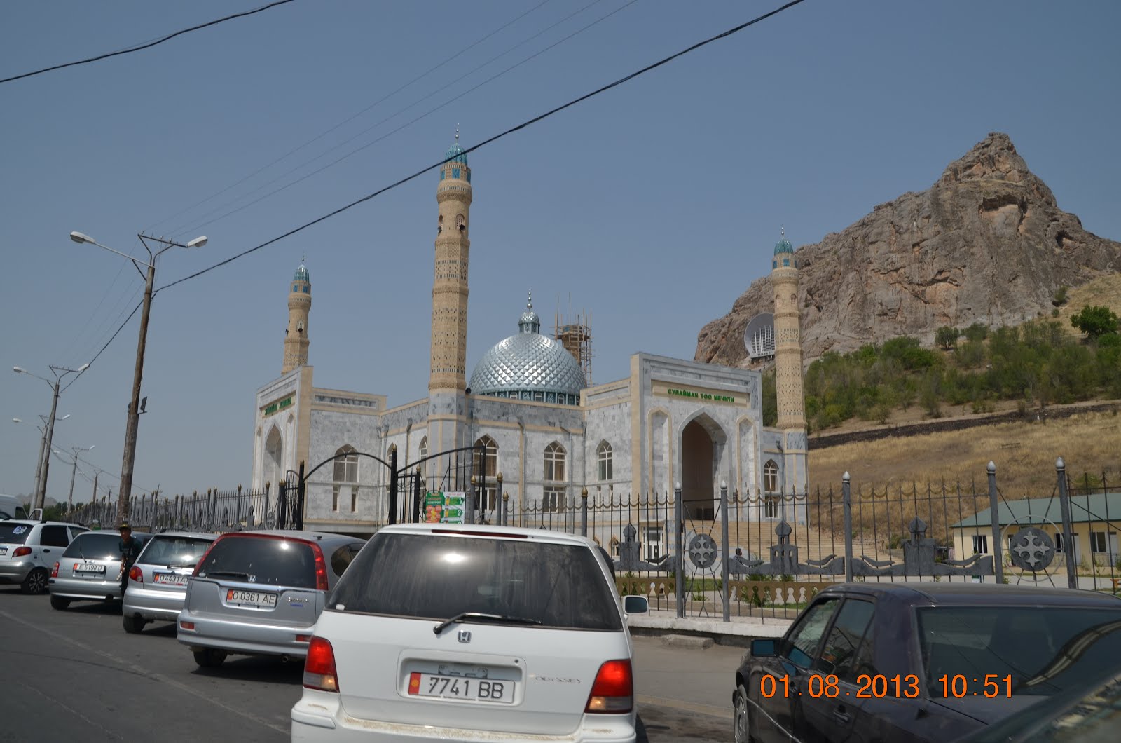
Sulaiman Too Mosque in front of Sulaiman Too mountain. The mosque is still in use for Friday prayers.


Osh Bazaar

We bought some of these fried bread, Osh Bazaar

'Horsepower' mural. On the left is a woman and on the right is a man riding a horse.

Osh city arch bidding us farewell as we left Osh city at noon.

Artwork at the Osh city arch.

Uzgen welcome Arch

Busy Uzgen market

Our lunch of manti and shishlik at Uzgen. The manti was tasty but the shishlik was underdone.

Crossing the bridge as we left Uzgen after our lunch.
It's the weekend and a hot day... locals are busy washing their cars, lorries etc and bathing in the river.
It's the weekend and a hot day... locals are busy washing their cars, lorries etc and bathing in the river.

We left the A370 and took the E010/M41 towards Jalal Abad

Arch at Jalal Abad. The statue of Manas stands in front of the arch.
Manas was the leader who united all the Kyrgyz tribes.
Manas was the leader who united all the Kyrgyz tribes.

On the E010 again, passing by a statue of a woman and possibly a child just outside of Jalal Abad.

Bazar Korgon Reservoir at sunset, less than 20km west of Jalal Abad.

Dinner at Kochkor Ata. It's chicken shashlik with paloo tonight.

Today we drove along the Naryn River, heading north for about 240km and end our day at Toktogul.

Turqoise green water of River Naryn is fed by glaciers and snow melts from the Tien Shan Mountains.. It run westward for 700km through Kyrgzstan and Uzbekkistan.


The highway heading north to Biskek along the Naryn River.

When in Rome we joined the locals ... Spent a couple of hours at this river to wash our Sorento. Dad chit chatting with a local family who drop by to swim in the clear water and wash their car..


The Mountains we see today are part of the Tian Shan mountain range that stretches from Tashkent in Uzbekistan and goes all the way to China.

Most of the Mountain ranges in Kyrgyzstan are part of the Tian Shan mountain range. Locally, each stretch are known by a different name. I believe this stretch is part of the Talas Ala-Too range.

Dam at Kurpsay, just one of several dams built along Naryn river. Kurpsay Dam is high pressure hydroelectric power station. The Dam and Lake Togtogul also help to regulate the River Nyrain

Bought some fried bread with potato and dill filling.

After crossing the tunnel, we paid the toll charges of 250 soms and carried on driving north.


Short break near Karakol City to have our simple lunch of fried bread with potato filling and salad. Pretty hot day, even the goats came and joined us under the shade.


Toktogul Reservoir - the largest along the Naryn river.


Lady sellinga big fish from the lake on the road side.

Near Toktogul City. We had our dinner (fish tonight!) and stayed the night here.
Will continue our drive to Bishkek tomorrow.

We left Toktogul in the morning and continued north on M41, driving through the picturesque Chychkan valley. Here, the M41 travels alongside the river Chychkan. We started at an elevation of about 1,500m and climbed all the way to more than 2,500m. At the end of Chychkan Valley, we ascended into Ala-Bel pass, the highest point of the pass stands at an elevation of 3,175m.

On this stretch of road about 40km north of Toktogul city, there are a lot of beekeepers.
Honey in clear bottles are put out for sale along the roadside.
After a while, we spotted a group of local beekeepers busy collecting honey a little further up the hill slope not too far from the roadside. We decided to have a look around.

Burning wood to create smoke.

Beekeeper holding up one of the frames. Not all the honeycombs are sealed on this frame. Only the sealed ones have honey in them.
The bees store the honey in honeycombs to be eaten later during winter time or whenever food is in short supply. The hardworking honey bees often produces more than they need allowing the beekeepers to collect the excess honey.


The frames full of honey are then arranged inside this barrel. The beekeeper spins the frames and the centrifugal force extracts the honey from the comb and collects it at the bottom of the barrel.
The honey is then collected in large containers and later put through a sieve to separate the debris from the clear gold liquid before it is packed in clear bottles for sale.

Me holding a piece of honey comb and the friendly local beekeepers. Before we left, we bought a bottle of honey and thank the beekeepers for sharing a part of their day with us.

Another family of beekeepers along the M41.

Enchanted by the beauty of Chychkan Valley.
Chychkan translates to 'mouse' in Krygyz.
The valley was so named due to the abundant of mice found here.
Chychkan translates to 'mouse' in Krygyz.
The valley was so named due to the abundant of mice found here.

In summer, the lush green Chychkan Valley is abundant with food, perfect for livestock. Numerous Krygyz nomad families settle here over the summer, setting up their yurts near the river. Livestock, which are predominantly horses, are left to graze up and down the mountain slopes.

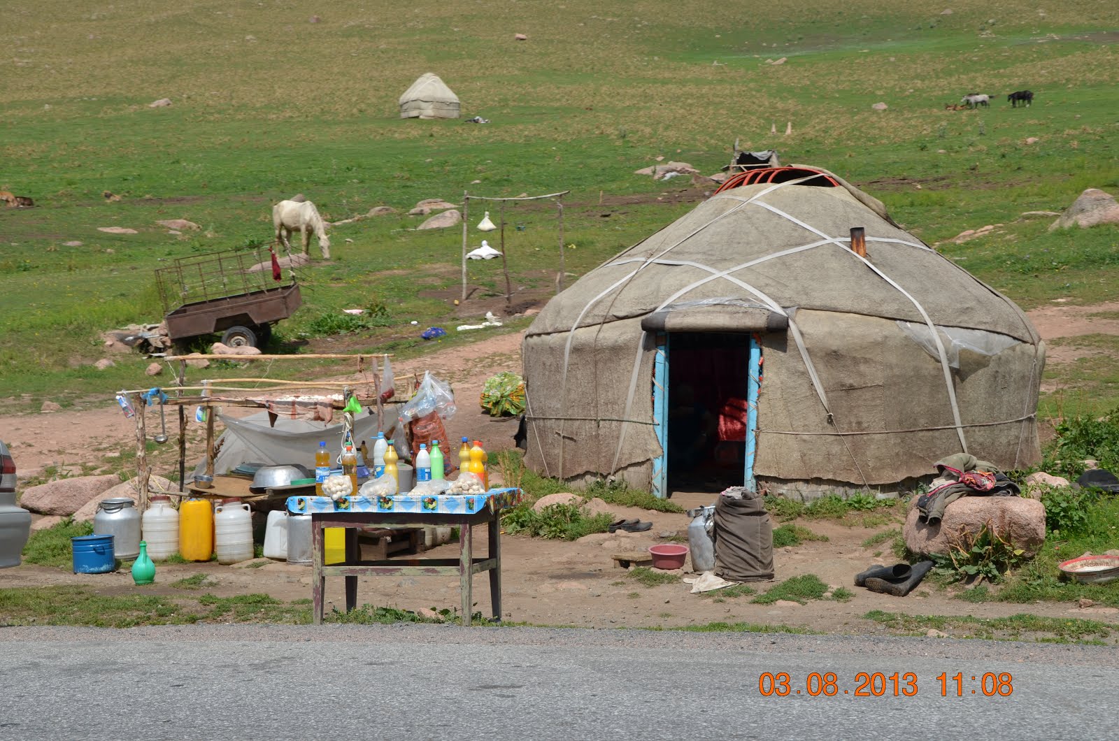
Stopped by this yurt to have a look at what the lady was busy making.
As it turns out, she was making kurut, a Kyrgyz nomad staple made of soured milk shaped into small balls and left to dry out and harden in the sun.
The first part of the process involves heating up fresh milk and leaving it to cool and ferment for a couple of days. The milk solid is then separated from the whey, producing strained yogurt or suzma. In this video we watched as the lady processed the suzma into kurut.

Helping mum to make cheese balls...

Tasting some kurut.. super hard to bite into. The flavour was pleasant but very salty.


As it turns out, she was making kurut, a Kyrgyz nomad staple made of soured milk shaped into small balls and left to dry out and harden in the sun.
The first part of the process involves heating up fresh milk and leaving it to cool and ferment for a couple of days. The milk solid is then separated from the whey, producing strained yogurt or suzma. In this video we watched as the lady processed the suzma into kurut.

Helping mum to make cheese balls...


Kurut put to dry out.

Making and selling kurut provides the local nomad families with additional side income... there are lots of small stalls selling kurut on the M41.

The lady's daughter showing us the inside of her yurt. This is our first peek into what it is like living in a yurt. Very homely and cosy. Large pieces of carpet line the wall to keep the warmth in and the wind out.

We gave the kids a packet of biscuits and after saying our goodbyes and thank yous, we left to continue our drive north.

Mum sitting down with her baby soaking up the summer sun.

Kids munching on snacks at the footsteps of their caravan.

Most of the nomad families here have horses. They are kept for meat and milk.

Fertile Valley, River of tranquility........in rural Kyrgyzstan
Kurut (dried cheese balls) and Kymyz (fermented mare's milk) for sale.

Kids in their tent...
At this point, we are about 2,440m above sea level and the weather is cool.


One on donkey and the other on a horse...

Already at the end of scenic enchanting Chychkan Valley.

The beginning of Ala-Bel Pass.
The Ala-Bel pass peaks at 3,175m above sea level and was once part of the ancient silk road.
Situated within the Talas Ala Too mountain range, the pass is connected to the Chychkan Valley in the west and the Suusamyr Valley in the east. Unlike most mountain passes, the Ala-Bel rises gently. Here's a video of our drive along the Ala-Bel pass.
Situated within the Talas Ala Too mountain range, the pass is connected to the Chychkan Valley in the west and the Suusamyr Valley in the east. Unlike most mountain passes, the Ala-Bel rises gently. Here's a video of our drive along the Ala-Bel pass.
Watch our videos on our Youtube channel >> https://www.youtube.com/channel/UCkuvmagkyCY-XqWZEKUOm-w
Driving further North west on M41 to Bishkek, capital of Kyrgyzstan.


Horses sent out to graze....

We stopped to watch...but the cowboys wanted us to pass....the horses waited nervously

Is dad sending his son to kindergarten ...?

Will be driving east briefly then turn north to Kara-Balta. Then we will turn east again to Bishkek on the M41. Bishkek is 197km away.

This boy is on an errand....bucket of milk or cheese balls?

At the junction to Talas. We won't be turning left to Talas though. Instead, we will continue north towards Bishkek.
Suusamyr Valley lies in between Ala-Bel Pass in the west and Too Ashuu Pass in the north. The M41 from Osh to Bishkek cuts through Suusamyr Valley.

Manas statue at the junction to Talas and the Kyrgyz/Kazakh border.
We continued east on the M41.

Just after the junction the roadsides are littered with small yurt cafes...

and some yurt hotels too.. they even come in two-storey...
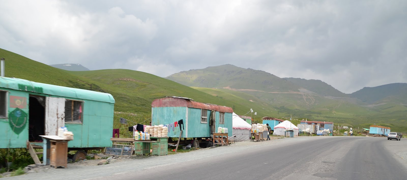
Local nomads selling traditional food namely Kurut and Kymyz.

The looping, snaky road up Too Ashuu Pass.
We are now at 2,900m above sea level. The pass goes up to about 3,200m.

The tunnel cuts through the mountain range. Took us less than 10 mins to come out on the other side.
The mountains in this section goes up to 3,400m above sea level. However, with the tunnel, we were driving mostly at about 3,180m above sea level.

It started to rain once we were out of the tunnel but we still managed to get a view of the rugged
Tien Shan Mountain Range.

As we descended the Too Ashuu Pass, the scenery changed a little with streams turning into mini water falls rushing down the side of the mountain. Taking a break to cool down our Sorento and touch the cool and clear mountain water.

As we descended the Too Ashuu Pass, the scenery changed a little with streams turning into mini water falls rushing down the side of the mountain. Taking a break to cool down our Sorento and touch the cool and clear mountain water.


Wildflowers and plants at 2,900m above sea level. We just love to drive on high altitude roads and passes, enjoying the cool mountain air and scenery.
Just outside of Sosnovka, there was a toll gate (toll charges was 250 som) and a police check point.
We arrive at Sosnovka at about 4.30pm. We were now out of the mountainous area and back onto flat land. After driving 56km from the top of Too Ashuu Pass with an elevation of nearly 3,200m, we are now at an elevation of less than 700m above sea level.
We did a bit of shopping for groceries and snacks at a supermarket in Sosnovka. We bought some chicken and later stopped at a village outside of Bishkek to cook our chicken curry dinner with rice. Getting a much needed dose of proper home cooked food!

Sunset.

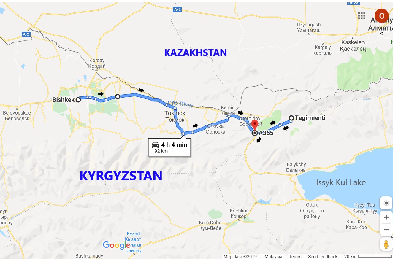
Here's the map with the route we traveled in this post.

Here's the map with the route we traveled in this post.
Sightseeing around Bishkek, capital city of Kyrgyzstan.
Osh Bazaar
First stop is Osh Bazaar, a nice place to have a glimpse into the daily lives of the locals. Even though it is almost noon time when we arrived at the bazaar, it was still packed with locals going about their day.


Osh Bazaar is the largest and busiest bazaar in Bishkek

The abundance of sesonal fruits......the joy of travel....cheap local fruits.


Fresh vegetables and fruits


A variety of nuts and dried fruits

The Kyrgyz staple, Kurut or dried cheese balls.

Mum is eyeing the cupcakes...


Kyrgyz men wearing the Ak Kalpak, the traditional Kyrgyz hat and a national cultural symbol.


You can find almost everything you need at this market.

Strawberries and raspberries sold by the bucket load
Manas Statue
Statue of Manas in front of the Philharmonic Hall


Ala Too Square


In front is the statue of Manas and the official flagpole of Kyrgyzstan guarded by two guards. The changing of the guards happens every hour.

Orlovka, well known for its ski resort in winter time.

We drove along Chu River on the A365, heading South East towards Issyk Kul Lake.


Fertile Green valley near Kaindy Village

Lots of birds on the electric wires


Bird with a caterpillar he caught on the dirt track near Tegirmenti

On the dirt track to Tegirmenti Village...

After asking for permission, we decided to camp here... not too far from the local family staying in their yurt.

The lady of the house served us some kymyz, mare's milk and something that looked like 'tauhu-pok' with fresh cream. The mare's milk is very light (ie. not as creamy as cow's milk) and has a sour tinge to it, definitely an acquired taste.
We made fried pasta noodles for dinner and gave some to the lady. The little kid got a packet of biscuits.

Tidying up the next morning...

The sun is rising very fast.

Tidying up the next morning...

The sun is rising very fast.

After saying our thank yous and good byes, we left our camp site by the yurt and retraced back our steps along Chong Kemin Valley to get back to the A365.

More birds on our way out to Issykul Lake


View of Chong Kemin Valley in the morning

Beekeeping at Chong Kemin Valley

Little calves soaking up the morning sun

Local vendors in yurts peddling their wares along the A365.
We are about 14km west of Balykchy town.
We are about 14km west of Balykchy town.

Balykchy Town
The gateway to Issyk-Kul Lake, this former fishing town is located on the western edge of Issyk-Kul Lake. Locals and tourists alike would stop for a break here .....to eat and buy smoked lake fish. cheese balls and fruits...and admire the lake view.
Issyk-Kul Lake smoked fish waiting for local/tourist to buy


More vendors peddling smoked fish and fruits by the buckets...apples, apricots and plums even dried cheese balls mostly bought by local and Kazakh tourists.

Apricots, nectarines and apples sold by the bucket

Buckthorn berries in glass jars.... and a couple of buckets of black currants... to make jam ...
The buckthorn berries and black currants makes up the bulk of wild berries produced in the Issyk-Kul region, all of which are for local consumption.
The buckthorn berries and black currants makes up the bulk of wild berries produced in the Issyk-Kul region, all of which are for local consumption.

Dad taking a closer look at Issyk-Kul smoked fish... only used to eat fresh sea fish... not entirely sure what to do with these..

Leaving Balykchy for Cholpon Ata Town, 77 km away.
We won't reach Cholpon Ata today though..
We won't reach Cholpon Ata today though..

Spending some time on the shores of Issyk-Kul Lake watching the sun set.
We are near Toru-Aygyr village.
We are near Toru-Aygyr village.

Dazzling Issyk-Kul Lake....
A short detour off A365 takes us to the Village of Almakuchkov nortth of Cholpon Ata iis an open area filled with acient boulder carvings of animals
Not every stone have ancient carvings... Not all the drawings are clear and not all the rocks are labeled.

A long horn ibex carving from the Turkic era.

Grave from the Sak-Usun period (8th century BC - 5th century AD).
Saka priests considered this area as sacred. It is believed that this area was an ancient temple used for various sacrifices and rites including worshipping the Sun God.

A goat with solar symbol (8th century BC - 5th century AD)

In the background, the Kungey Ala Too mountains...

Cholpon Ata Bazaar
Main market selling all sorts of local produce and smoked fish from Issyk-Kul Lake. Unlike other places we have travelled to so far in Kyrgyzstan, the businesses here were dominated mostly by local Russians and Khazaks. Very few locals run fruit and vege stalls in the Bazaar.Cholpon Ata is also a summer resort on the northern shore of Lake Issyk Kul. In summer it is quite crowded, full of wealthy Kazakhs, Russian and a few locals.


Russian girl selling smoked fish...

Smoked meat and sausages

Vege and fruits are sold by locals

Local Russians buying local bread

Local berries and peaches.

We bought grapes, apricots, nectarins, plums, berries and some veges at the bazaar.

We also decided to get the smoked fish.
We left Cholpon Ata and drove on the A363 towards Karakol

Wheat fields near Semenovka. Cloudy and starting to drizzle. Temperature about 24°C. Elevation about 1,600m above sea level.

War memorial near Jarkynbaebo

Cowboys guiding their herd home... near Chong Oruktu village.
Karkyra Valley
Outside of Tyup village, we turned left onto A362 and continued east into Karkyra Valley
Karkyra Valley goes on for 60km from Tyup village to the Kyrgyz/Kazakh border further east.

Wall art at Taldy-Su village

Old houses with Russian style decorative windows...


2nd World War Memorial

Rural bus service at Koochu

Young cowboys at Jiluu Bulak

Ladies walking to Jiluu Bulak


This road is our favourite route drive to the Chinese Border.

Old trucks are used to move the bee hives.


Crossing the bridge over river Tyup. At this point, we leave the A362 and Karkyra Valley to enter the A364 heading southwest towards beautiful green Jergalan.
This area is sparely inhabited with lots of grasslands.


The dirt track that is the A364. Gentle climb from 1900m to 2100m above sea level.

View of the remaining of Karkyra Valley from a viewpoint on the A364

Our Sorento on the A364 dirt track
Oops.. road block
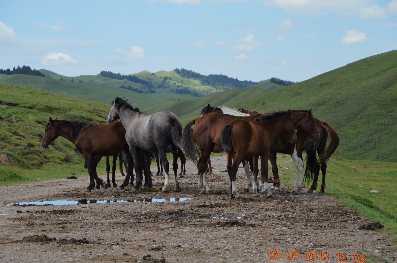
Just like cows, horses too like to hang around on the road... mess up the road...too

A cowboy in Central Asia..

Beautiful horses. These horses are large.

Just stay cool guys...

Ya me the odd one... i know


Heavy with a baby...


Further beyond......more
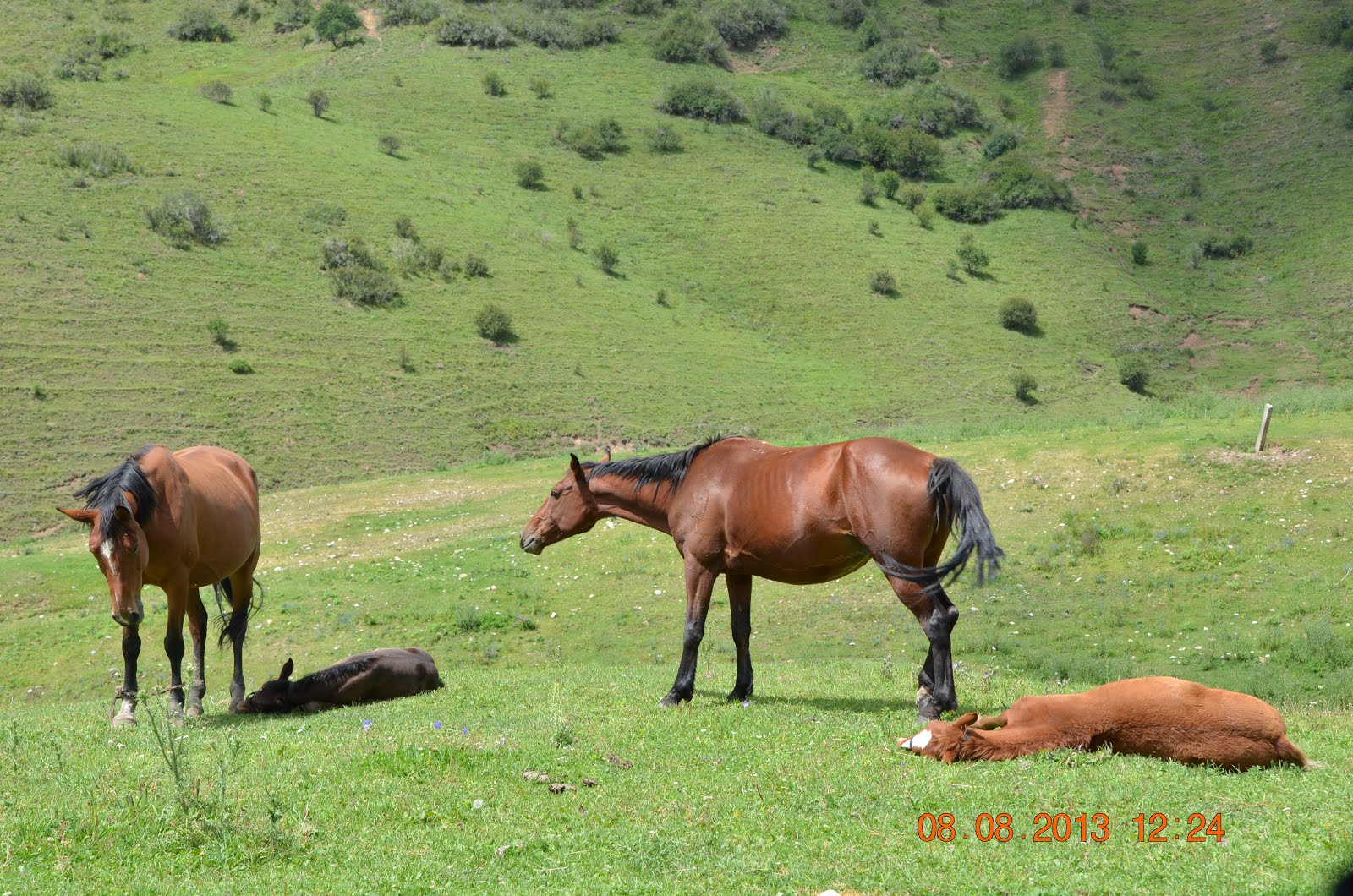
Mum on left is shading her foal....mum on right is getting agitated by our presence.

Owner of the horses. Horses are also berd for their meat in Krygzistan

These horses are bred for their meat.
We found a nice quiet spot away from the horses and stopped to have our lunch.
Then, mum cooked dinner as well - rice with fried aubergine and potatoes. At about 4pm, we left and made our way to Jergalan. Here, we left the A364 and turned right onto A363, driving southwest to Ak Suu
On the A363 from Jergalan to Ak Suu

Lots of crows in the grassland at Kyzyl-Kyja village (near Jergalan).

Rushing back to get more load.. at Ak Suu village

The kalpak is perhaps the most famous item of clothing in Kyrgyzstan. A tall hat, made of white felt, it is usually worn by men after the age of six.

Wooden Russian Orthodox Church at Ak Suu

Mum I am coming with you....
From Ak Suu, we turn south to drive explore Arashan River


This is a deour to follow the swoolen stream


Arashan River

It rained earlier on and the river is gushing

Almost bursting its banks..

We are now about 10km south of Ak Suu Village. The puddles of water are getting more frequent and some are deep. We had already dented and loosen our side steps after hitting a rock that was submerged in an earlier puddle.

After checking the condition of the dirt road we decided to turn back,
not taking the risk, we made a u-turn and retraced our steps back to Ak Suu. Would have been nice to be able to go further to check out the view and the hot springs though.
Karakol City
is a major city on the south eastern edge of Issyk-Kul Lake and the fourth largest city in Kyrgyzstan.
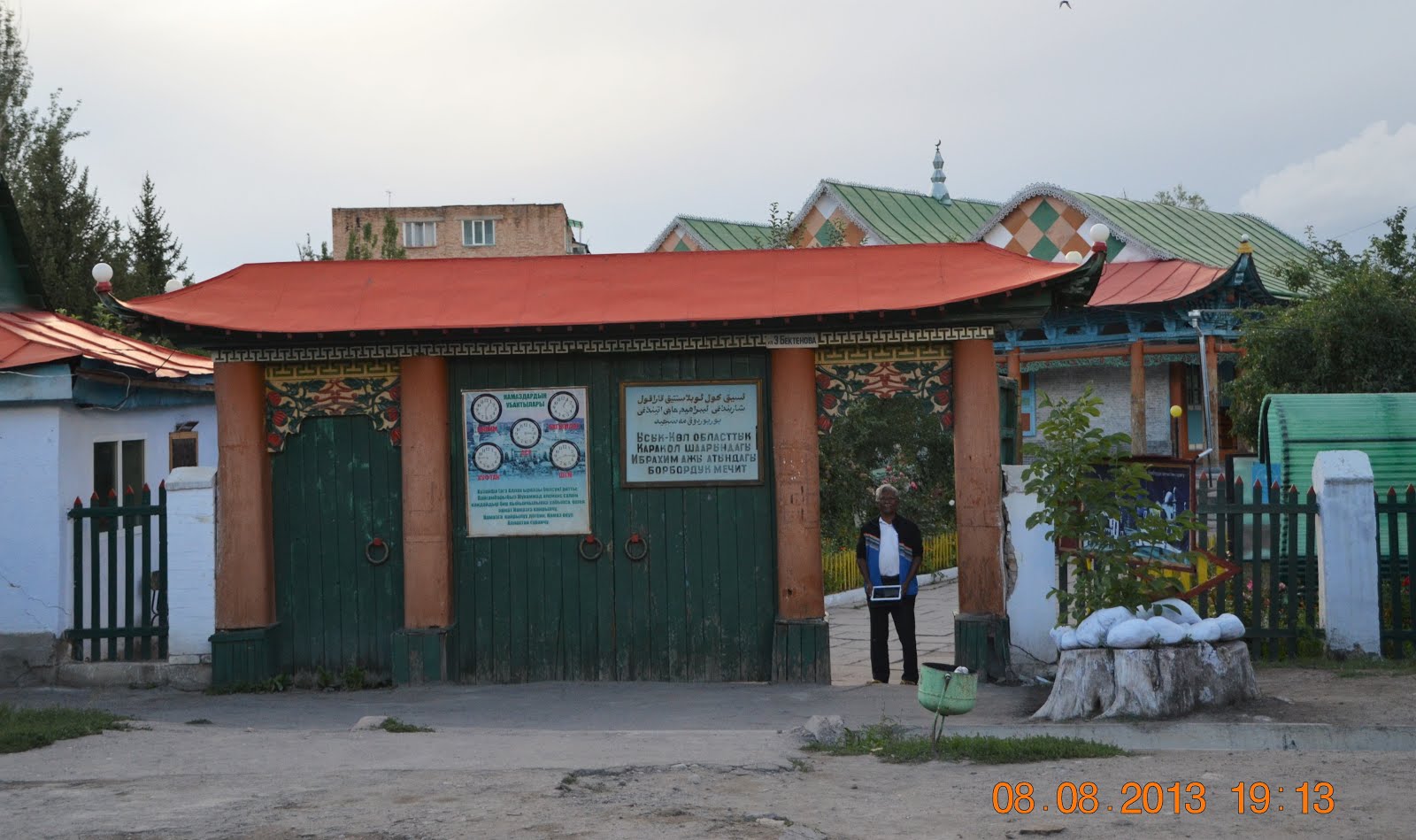
Dungan Mosque in Karakul
The Dungan mosque with distinctive Chinese influence was built by the Dungan community, the Chinese Muslim refugees who fled persecution in their home country in the late 1800s.

Dungan Mosque was built around 1904-1907 with interlocking wood and no nails.

The Mosque survived the Soviet era and is still in very good shape.
Blue is the dominant colour. Other colours are green, yellow and red.
These colours have symbolic meaning in the Dungan culture - green represents happiness, yellow means wealth and prosperity and red is protection from evil spirits

Intricate carvings of plants and fruits such as grapes, peaches and pomegranates on the cornices surrounding the mosque. The corners of the roof are decorated with carvings of dragons.

The interior of Dungan mosque
The Mosque"s Main gate

Taking another detour to se Jeti Oguz, translates as ‘Seven Bulls’,
It is lacated bout 30km south of Karakul City, the name comes from the large red-rock cliffs that resemble, you guessed it, seven bulls.


Two of the seven bulls.
They do look like a stack of pancakes...

The Seven Bulls Rock

Jeti Oguz Village

The 'Heart break' Rock


Some of the yurts are are actually small cafes..


Mobile bee keeping at the foot of the hill..
We bought a jar of honey before leaving Jeti Oguz.

No motorcycle... A horse beats walking..
We drove back to A365 after the detour to Jeti Orguz

Issyk-Kul Lake near Ak-Terek.
Issykul Lake, meaning Warm Lake in Kyrgyzstan... is a high altitude (1600m above sea level) saline lake that never freezes over in winter. The Lake is ringed by snow-capped Tien Shan Mountains that averages above 3,500 meters. Driving along the southern shores to Kochor
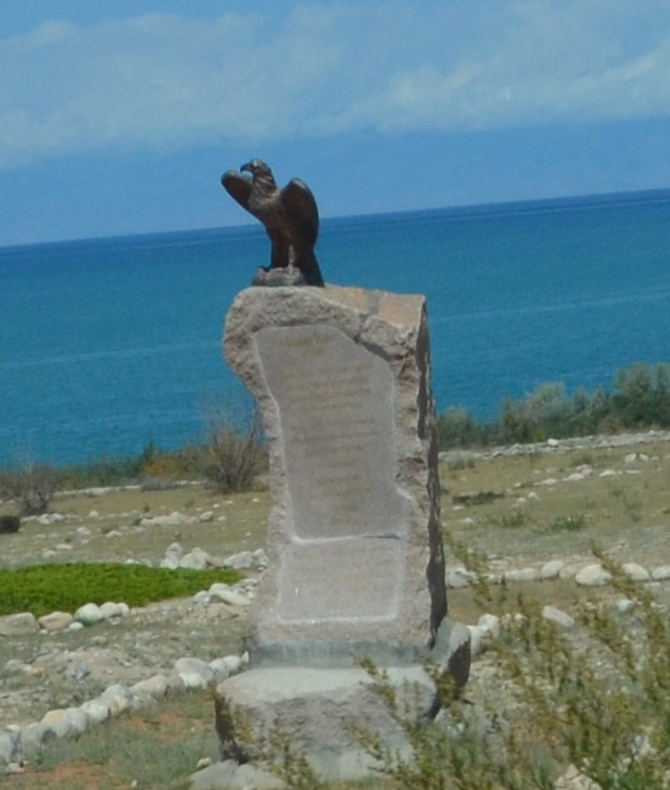
Eagle Monument on the southern shores of Issykul Lake

Issykul Lake is the 2nd largest alpine lake in the world, after Lake Titicaca.
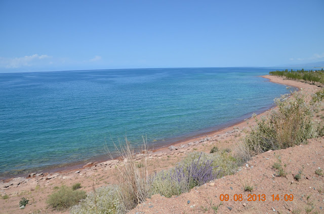
Clear waters of Issyk Kul Lake

____________________

Clear waters of Issyk Kul Lake

____________________
Kaji-Say to Bokonbayevo

Complex Alaam Ordo, about 5km east of Kaji-Say village.
The gates were locked but we could still catch a glimpse of the compound.

Concrete yurt structures and walls with paintings line the perimeter

The murals lining the perimeter shows the local culture and way of life

Eagle hunting an ancient tradition important to the Kyrgyz nomads.
These trained golden eagles to help the nomads find food in the wilderness.

Men fighting corruption (represented by the dragon)

Beach near Bokonbayevo
Turning south along A365 leaving Issyk Kul Lake we headed for Kochkor.

Bactrian camels making their way home.

Driving along Chu River on the A365 to Kochkor
Driving leisurely South-westwards taking in the sights and views from Kochor to Song Kul Lake.


From a distance, this looked like a small settlement with ornately constructed structures...

mostly made of mud or clay... some with perimeter fencing or walls...
In reality, this is the local cemetary just outside of Kochkor village. Some of the graves are quite old
We start our day at Kochkor and the plan for today is to travel to Son-Kul Lake.
First, we spend some time walking around Kochkor bazaar. At a nearby, supermarket we bought some groceries, cookies and snacks.
We start our day at Kochkor and the plan for today is to travel to Son-Kul Lake.
First, we spend some time walking around Kochkor bazaar. At a nearby, supermarket we bought some groceries, cookies and snacks.

Kyrgyzstan gentleman..and his tall hat, struts proudly by..

Horse milk in a barrel...

Kochor Bazaar

Old man with traditional hat taking a break

On the A365, near Sarybulak. Elevation 2,260m above sea level.
About 4km south of Sarybulak, we leave the A365 and turned right into the road that will take us up the mountain range to Son-Kul Lake.

Entering Karatal Japyryk Nature State Reserve
About 4km south of Sarybulak, we leave the A365 and turned right into the road that will take us up the mountain range to Son-Kul Lake.

Entering Karatal Japyryk Nature State Reserve

At the top of the hill, taking in the views of the distant mountains and valleys..
All part of central Tien Shan mountain range.
We are about 2,500m above sea level at this point.

Kid at Keng-Suu village saluting us... his way of saying hello and goodbye...
We are about 2,620m above sea level now and it is cold.

Kyrgyz jailoos ie summer pastures. Following Tolok River south westward. to Lake to Naryn

The three amigos..

We are about 3,000m above sea level and a lone Yaks in the pastures,. this fella is huge..

Slightly over 1pm now. at elevation 3,118m. on A365. The Kalmak Ashuu Pass goes up to 3,446m before descending.. we still have a bit more climbing to do.

At the peak of the Kalmak Ashuu Pass. Elevation 3,450m.
Looking down at the road that will take us to Son Kul Lake.

Horse back riding activity... In the background, just a bit of snow left on the mountain top... In winter time, this whole area would be covered in snow and the gravel road that we are driving on now would be closed.

Mini glacier...

Horse trying to scratch an itch on his hind leg..

Kid on a donkey waiting for his friend so they can ride together...

One of many Kyrgyz jailoos or summer pastures where herds of sheep, goats, horses etc graze in summer. There must be hundreds of sheep and goats on this section alone..
In the distance, barely visible, is Son-Kul Lake.

Dad and the large flock of sheep and goats.

Mum and her foal soaking up the summer sun...

Driving on the southern shores of Son-Kul Lake in search of a nice spot to camp.

Yurt with a lada van and a herd of horses

Gazing at grazing sheep at Son kul Lake ... taking in the sights ... too...the fresh air...
Should be nice to camp here ....with the yurts, sheep, horses, the Son-Kul lake..


The two best friends up and grazing again...
Looking down at the road that will take us to Son Kul Lake.

Horse back riding activity... In the background, just a bit of snow left on the mountain top... In winter time, this whole area would be covered in snow and the gravel road that we are driving on now would be closed.

Mini glacier...

Horse trying to scratch an itch on his hind leg..

Kid on a donkey waiting for his friend so they can ride together...

One of many Kyrgyz jailoos or summer pastures where herds of sheep, goats, horses etc graze in summer. There must be hundreds of sheep and goats on this section alone..
In the distance, barely visible, is Son-Kul Lake.

Dad and the large flock of sheep and goats.

Mum and her foal soaking up the summer sun...

Driving on the southern shores of Son-Kul Lake in search of a nice spot to camp.

Yurt with a lada van and a herd of horses

Gazing at grazing sheep at Son kul Lake ... taking in the sights ... too...the fresh air...
Should be nice to camp here ....with the yurts, sheep, horses, the Son-Kul lake..

Ooh it's juicy ...I will kneel to eat all...

The two best friends up and grazing again...

Not far from where we camped is a Yurt camp with horse riding activities waiting for the arrival of the tour group on the next day.

The next day... having a lazy day at Son-Kul Lake.
Drizzled a bit with some hail stone shower.
Drizzled a bit with some hail stone shower.

Cold and windy.... we had to cook our own meals as there is no shops around.....just nature and the sheep, goats and horses to keep us company.....as the night might be cold and wet we came prepared with an extra layer of tent cover to keep the cold wind and rain out...

Today, the horses kept us company

Son Kul Lake... 3,016m above sea level
is the second largest alpine lake in Kyrgyzstan after Issyk-Kul Lake
is the second largest alpine lake in Kyrgyzstan after Issyk-Kul Lake
Liking the place we camped, we rested at Son Kul Lake for 2 nights and left late in the morning on 12 Aug 2013.
Map of our route from Kochkor to Son-Kul Lake
We had our half boiled eggs with bread and tea for breakfast and prepared a simple lunch to have later on our way through the Mountain Pass.
We left Son-Kul Lake and make our way down to Naryn city via the Moldo Ashuu pass.
We left Son-Kul Lake and make our way down to Naryn city via the Moldo Ashuu pass.

After driving for about 13km, we are at Moldo Ashuu Pass.
At this point the elevation is 3,250m. Moldo Ashuu Pass goes up to 3,346m above sea level.
From here, the dirt road zig zags, jumping from the side of one hill to the next as we make our way to lower ground.

The seven hairpins that will take us down to the valley which is at an elevation of 2,600m above sea level.

Our Sorento and the hairpin turns on the left.

At Moldu Ashuu Pass
A video of us driving down one of the hairpins Go to Home to see this video
Watch our videos on our Youtube channel >> https://www.youtube.com/channel/UCkuvmagkyCY-XqWZEKUOm-

Driving in the valley with the rocky mountain towering on either side.

Alpine forest on rocky mountains

AGPS reading an elevation of 2,500m

We stopped a little further up to have our prepared lunch.
We are now at an elevation of about 2,280m.

After about an hour, it started to rain and the whole area where we were was covered in mist and cloud. The rain went on for another half hour as we continued our slow drive.

Thought it was a waterfall up ahead but it was just the wet tarred road.....mirage?

Elevation down to 1,700m now. Crossing the swollen River Naryn near Ak-Tal village.

Old tractor at Ak-Tal Village

Naryn town in the distance. The town is on the banks of Naryn River and in the olden days, it was a fortress along the caravan route from China.

View of the snow capped Mountains Ak Tal Village, near to Nayrn Town.
Entering Naryn Town.

Freedom statue in the Main Square.
We parked here to look around. Then an old man approached us and was pointing to our car. As ours was the only car parked here... we thought he was trying to tell us that we were not supposed to park here. As it turned out, his keen eyes had spotted the puncture on one of our tyres and he was actually gesturing for us to quickly drive to the tyre shop before the tyre goes completely flat....thank you Uncle.


We left immediately in search of a tyre repair shop after getting some directions from the old man.
Found this shop with a very tiny door as entrance to the workshop....

X marks the spot. The puncture was quite big.. We must have picked it up when we were going through a long stretch of rough dirt road earlier.


Repairing our puncture.. the old fashioned way.. Our tyre was taken off the rim and the inside lining inspected.

The puncture is then sealed with a plug and placed on this machine the old way that applies both pressure and heat to bond the patch to the tyre lining. Took a bit of time but it was a good repair. Unlike dad, this is the first time I have ever seen a puncture repaired this way, with the simple puncture kit which takes a couple of minutes and does not require the tyres to be taken off the rim.. so this was a good experience.
For good measure, we also had our spare tyre checked before leaving.

Back on the road..

Beautiful blue Mosque in Naryn

Found this noodle shop in Naryn Town. Tucking in our Lunch at a noodle shop.
quite good we enjoyed ......

We had a bowl of laghman with tea and bread. Just nice as the weather is cold outside.
After changing some Som and fueling up, we left Naryn to rejoin the A365 and head south to visit Tash Rabat Caravanserai.

We had a bowl of laghman with tea and bread. Just nice as the weather is cold outside.
After changing some Som and fueling up, we left Naryn to rejoin the A365 and head south to visit Tash Rabat Caravanserai.

Waiting for the bus.....good bye mate.

Street vendor selling veges and melon at Naryn.

Back on the A365, Torugart Pass and China/Kyrgyzstan Border


Statue of a prancing horse near the junction to Ak-Muz
At-Bashi village

At-Bashi Town in the distance. In the background is the Bashi Mountain Range (part of the Tien Shan Mountain Ranges) that stretches all the way to Torugart Pass and the Kyrgyz border with China.

Statue of Manas, At-Bashi village


Local bazaar.. we picked up a melon before moving on.

Sheep skin for sale at At-Bashi Bazaar
A short detour.. the new road still under construction...

Having to cross this river here.

Back on the newly built road 5 minutes later.

Crossing the bridge over At-Bakshi River

Just ahead is he junction where we turn left.to visit the ancient Tash Rabat Caravanserai.
Tash Rabat Caravanserai is a well preserved ancient stone relic from the 15th century. It used to provide shelter to traders, merchants and travelers on the old Silk Road. Located inside the At-Bashy mountain range, with the structure half tucked into the mountain side, our drive in the valley takes us through some pretty scenic Rocky mountains outcrops
Turning off the main A365 and onto the dirt road that goes through the At-Bashy Mountain Range to Tash Rabat Caravanserai where as what the Silk Road travellers and traders did, we will be camping the night there too.

Driving along a stream as we enter the valley

The Yurt camp near Tash Rabat

Dramatic rocky mountains


Arriving at The Tash Rabat Caravanserai tucked into the mountain side.

We are now more than 3,100m above sea level.

We will visit the caravanserai in the morning. In the meantime, continuing to drive further in to see the view.

Our Sorento and the At-Bashy Mountain Range all misty and mysterious

No more track.. that's as far as Our Sorento can go...

View of the valley in the distance. .

We returned to the caravanserai and enquired about a yurt stay nearby..

Choosing our yurt

Nicely decorated with enough beds for 5 people.


Latice side walls with reed mat lining hold up the poles for the roof of the yurt

The centre of the roof with the circle is called the tunduk. A piece of felt covers the circle and attached to a string that is then used to open and close the flap to allow fresh air and light in when needed.

A small iron stove used to heat up the interior or even make some tea.
Dried animal dung is used as fuel. We had earlier bought some fish and mum is frying it up so we can keep it for our lunch tomorrow.

A small iron stove used to heat up the interior or even make some tea.
Dried animal dung is used as fuel. We had earlier bought some fish and mum is frying it up so we can keep it for our lunch tomorrow.

Felt and wool covering the entire structure on the outside.
Stayed the night in this basic Yurt with Sorento safe outside. Note the Caravanseri in the background.

The felt flap that is the door is really thick and heavy.


The felt flap that is the door is really thick and heavy.

We make our way to the yurt owner's house for dinner, served at 8pm. The rental for the yurt includes Krygzistan food, Buffet dinner and Breakfast.

Kuurdak - mutton with potatoes and veges

Shorpo - soup dish with meat, wheat / barley and vegetables

Cucumber and tomato salad

The whole dinner spread. Boorsok on the bottom right.
Krgyz non / bread is also served together with tea, some sweats and jam.
Click here for more info on these local dishes.
There was another group of tourists with their guide having dinner too. They were spending 7 days touring Kyrgyzstan. We chatted for a couple of hours after dinner and went to bed at 10.30pm.
The next morning, our breakfast was wheat / oats porridge, pancakes, bread, home made black currant and apricot jam and tea with some sweets. The apricot jam was good, we bought a jar for the road.
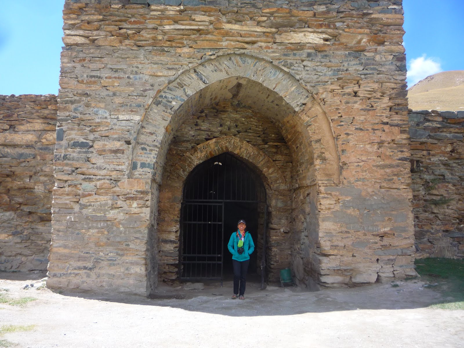
The Tash Rabat Caravanserai.
This was once a place of shelter for traders and merchants travelling on the old Silk Road.
According to Wikipedia, the caravanserai may have been built even before that... in the 10th century, when it served as a Christian monastery..
Now mostly catering to tourists and a good stopping point for overlanders like us before taking the Torugart Pass to cross the border to China.
Now mostly catering to tourists and a good stopping point for overlanders like us before taking the Torugart Pass to cross the border to China.

The well preserved 15th century stone structure, Tash Rabat Caravanserai


The large dome on the top..

Mum at the entrance of the caravanserai
Me at the entrance..


The doorways are quite small..


The doorways are quite small..


The dome roof

As we were leaving the caravanserai, a whole group of tourist have just arrived.

A couple of marmots foraging for food on the slopes behind the caravanserai.
Back on to the A365 and continue our drive to Torugart Pass.
The Kyrgyz / China border.(Post on China will be under ...C...)
No comments:
Post a Comment